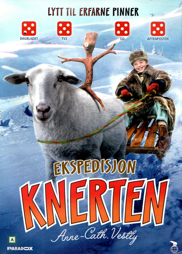
Ekspedisjon Knerten
Ekspedisjon Knerten
DVD · Bokmål · 2018 · Adaptasjoner (film)
| Medvirkende | |
|---|---|
| Omfang | 1 DVD (1 t, 13 min)
|
| Passer for | |
| Opplysninger | Basert på Anne Cath. Vestlys figurer. - I den fjerde filmen om Knerten flytter Lillebror og familien til Vestlandet. Med på lasset er selvfølgelig Knerten, Karoline og Lille-Knerten. På vei over fjellet fantaserer Lillebror og Knerten om å dra på et ordentlig eventyr, som Roald Amundsen. Dessverre regner denne fantasien fullstendig bort når de ankommer sitt nye hjem i Bergen. Filmen fikk terningkast 3-5 av norske anmeldere. Omtalen er utarbeidet av BS.
|
| Sjanger | |
| Geografisk emneord |
- Alta bibliotek har 0 av 0 ledig (Oppdaterer)
- Alvdal bibliotek har 0 av 0 ledig (Oppdaterer)
- Alver bibliotek: Knarvik har 0 av 0 ledig (Oppdaterer)
- Andøy folkebibliotek har 0 av 0 ledig (Oppdaterer)
- Andøy videregående skole: Biblioteket har 0 av 0 ledig (Oppdaterer)
- Arendal bibliotek har 0 av 0 ledig (Oppdaterer)
- Askerbibliotekene: Asker bibliotek har 0 av 0 ledig (Oppdaterer)
- Askim videregående skole: Biblioteket har 0 av 0 ledig (Oppdaterer)
- Aurskog-Høland bibliotek har 0 av 0 ledig (Oppdaterer)
- Austrheim bibliotek: Hovudbiblioteket har 0 av 0 ledig (Oppdaterer)
- Bergen Offentlige Bibliotek: Hovedbiblioteket har 0 av 0 ledig (Oppdaterer)
- Biblioteka i Sunnfjord kommune: Førde bibliotek Hovudbiblioteket har 0 av 0 ledig (Oppdaterer)
- Biblioteka i Sunnfjord kommune: Sande bibliotek i Sunnfjord har 0 av 0 ledig (Oppdaterer)
- Bjerkreim folkebibliotek har 0 av 0 ledig (Oppdaterer)
- Bjertnes videregående skole: Biblioteket har 0 av 0 ledig (Oppdaterer)
- Bjørkelangen videregående skole: Biblioteket har 0 av 0 ledig (Oppdaterer)
- Bjørnafjorden bibliotek : Eikelandsosen har 0 av 0 ledig (Oppdaterer)
- Bjørnafjorden bibliotek: Hovudbiblioteket har 0 av 0 ledig (Oppdaterer)
- Bleiker videregående skole: Biblioteket har 0 av 0 ledig (Oppdaterer)
- Bodin videregående skole: Bibliotekfaglig ressurssenter har 0 av 0 ledig (Oppdaterer)
- Bodø videregående skole: Biblioteket har 0 av 0 ledig (Oppdaterer)
- Borg videregående skole: Biblioteket har 0 av 0 ledig (Oppdaterer)
- Brønnøy bibliotek Brønnøysund: Hovedbiblioteket har 0 av 0 ledig (Oppdaterer)
- Brønnøy bibliotek Velfjord har 0 av 0 ledig (Oppdaterer)
- Brønnøysund videregående skole: Biblioteket har 0 av 0 ledig (Oppdaterer)
- Buskerud videregående skole: Avdeling Rosthaug Skolebiblioteket har 0 av 0 ledig (Oppdaterer)
- Bærum bibliotek: Hovedbiblioteket Bekkestua har 0 av 0 ledig (Oppdaterer)
- Bø folkebibliotek: Hovedbiblioteket har 0 av 0 ledig (Oppdaterer)
- Bømlo folkebibliotek: Hovudbiblioteket Svortland har 0 av 0 ledig (Oppdaterer)
- Deichman Bjørvika har 0 av 0 ledig (Oppdaterer)
- Drammen videregående skole: Biblioteket har 0 av 0 ledig (Oppdaterer)
- Drammensbiblioteket har 0 av 0 ledig (Oppdaterer)
- Drangedal bibliotek har 0 av 0 ledig (Oppdaterer)
- Drømtorp videregående skole: Biblioteket har 0 av 0 ledig (Oppdaterer)
- Dønna bibliotek: Hovedbiblioteket har 0 av 0 ledig (Oppdaterer)
- Dønski videregående skole: Biblioteket har 0 av 0 ledig (Oppdaterer)
- Eidsvoll videregående skole: Biblioteket har 0 av 0 ledig (Oppdaterer)
- Eigersund folkebibliotek: Hovedbiblioteket har 0 av 0 ledig (Oppdaterer)
- Eikeli videregående skole: Biblioteket har 0 av 0 ledig (Oppdaterer)
- Elverum bibliotek har 0 av 0 ledig (Oppdaterer)
- Etnedal folkebibliotek har 0 av 0 ledig (Oppdaterer)
- Farsund bibliotek: Hovedbiblioteket har 0 av 0 ledig (Oppdaterer)
- Fauske bibliotek: Hovedbiblioteket har 0 av 0 ledig (Oppdaterer)
- Fauske videregående skole: Avd. Vestmyra Biblioteket har 0 av 0 ledig (Oppdaterer)
- Fedje folkebibliotek: Hovudbiblioteket har 0 av 0 ledig (Oppdaterer)
- Flå folkebibliotek har 0 av 0 ledig (Oppdaterer)
- Frederik II videregående skole: Biblioteket har 0 av 0 ledig (Oppdaterer)
- Frogn bibliotek har 0 av 0 ledig (Oppdaterer)
- Frogn videregående skole: Biblioteket har 0 av 0 ledig (Oppdaterer)
- Fylkesbiblioteket i Akershus, Buskerud og Østfold - Kjeller har 0 av 0 ledig (Oppdaterer)
- Fyresdal folkebibliotek har 0 av 0 ledig (Oppdaterer)
- Fyrverkeriet bibliotek, Vestre Toten har 0 av 0 ledig (Oppdaterer)
- Gjøvik bibliotek og litteraturhus: Hovedbiblioteket har 0 av 0 ledig (Oppdaterer)
- Glemmen videregående skole: Biblioteket har 0 av 0 ledig (Oppdaterer)
- Gloppen folkebibliotek har 0 av 0 ledig (Oppdaterer)
- Gol bibliotek har 0 av 0 ledig (Oppdaterer)
- Greåker videregående skole: Biblioteket har 0 av 0 ledig (Oppdaterer)
- Gáivuona girjerádju - Kåfjord bibliotek - Kaivuonon biblioteekki: Valdogirjerájus - Hovedbiblioteket har 0 av 0 ledig (Oppdaterer)
- Gáivuona girjerádju - Kåfjord bibliotek: Olmmáivákki ossodat - Manndalen filial har 0 av 0 ledig (Oppdaterer)
- Hadsel videregående skole: Biblioteket Melbu har 0 av 0 ledig (Oppdaterer)
- Hadsel videregående skole: Skolested Stokmarknes Biblioteket har 0 av 0 ledig (Oppdaterer)
- Halden fengselsbibliotek har 0 av 0 ledig (Oppdaterer)
- Hamar bibliotek har 0 av 0 ledig (Oppdaterer)
- Hamar bibliotek: Avdeling Vang har 0 av 0 ledig (Oppdaterer)
- Hammerfest bibliotek: Hovedbiblioteket har 0 av 0 ledig (Oppdaterer)
- Hasvik folkebibliotek har 0 av 0 ledig (Oppdaterer)
- Heim bibliotek: Avd. Halsa har 0 av 0 ledig (Oppdaterer)
- Heim bibliotek: Hovedbiblioteket har 0 av 0 ledig (Oppdaterer)
- Hemsedal folkebibliotek har 0 av 0 ledig (Oppdaterer)
- Hjartdal folkebibliotek har 0 av 0 ledig (Oppdaterer)
- Hof bibliotek har 0 av 0 ledig (Oppdaterer)
- Hol folkebibliotek: Geilo hovedbibliotek har 0 av 0 ledig (Oppdaterer)
- Hol folkebibliotek: Hol filial har 0 av 0 ledig (Oppdaterer)
- Hol folkebibliotek: Hovet filial har 0 av 0 ledig (Oppdaterer)
- Holmen grunn- og videregående skole: Biblioteket har 0 av 0 ledig (Oppdaterer)
- Holmestrand bibliotek har 0 av 0 ledig (Oppdaterer)
- Hvam videregående skole: Biblioteket har 0 av 0 ledig (Oppdaterer)
- Hå bibliotek avd. Ogna har 0 av 0 ledig (Oppdaterer)
- Hå bibliotek avd. Varhaug har 0 av 0 ledig (Oppdaterer)
- Hå bibliotek: Hovudbiblioteket har 0 av 0 ledig (Oppdaterer)
- Jessheim videregående skole: Læringssenteret har 0 av 0 ledig (Oppdaterer)
- Kalnes videregående skole: Biblioteket har 0 av 0 ledig (Oppdaterer)
- Kirkeparken videregående skole: Biblioteket har 0 av 0 ledig (Oppdaterer)
- Klepp bibliotek har 0 av 0 ledig (Oppdaterer)
- Kongsberg bibliotek: Hovedbiblioteket har 0 av 0 ledig (Oppdaterer)
- Kongsberg videregående skole: Maurits Hansen-biblioteket Tinius Olsen-biblioteket har 0 av 0 ledig (Oppdaterer)
- Kongsvinger bibliotek har 0 av 0 ledig (Oppdaterer)
- Kragerø bibliotek har 0 av 0 ledig (Oppdaterer)
- Kristiansand folkebibliotek: Hovedbiblioteket har 0 av 0 ledig (Oppdaterer)
- Kulturbadet bibliotek har 0 av 0 ledig (Oppdaterer)
- Kviteseid Folkebibliotek har 0 av 0 ledig (Oppdaterer)
- Kvænangen folkebibliotek har 0 av 0 ledig (Oppdaterer)
- Lier videregående skole: Biblioteket har 0 av 0 ledig (Oppdaterer)
- Lillesand folkebibliotek har 0 av 0 ledig (Oppdaterer)
- Lillestrøm videregående skole: Biblioteket har 0 av 0 ledig (Oppdaterer)
- Lillestrømbibliotekene, Fetsund har 0 av 0 ledig (Oppdaterer)
- Lillestrømbibliotekene, Frogner har 0 av 0 ledig (Oppdaterer)
- Lillestrømbibliotekene, Skedsmokorset har 0 av 0 ledig (Oppdaterer)
- Lillestrømbibliotekene, Strømmen har 0 av 0 ledig (Oppdaterer)
- Lillestrømbibliotekene, Sørumsand har 0 av 0 ledig (Oppdaterer)
- Lindesnesbibliotekene Bjelland har 0 av 0 ledig (Oppdaterer)
- Lindesnesbibliotekene Fengselet har 0 av 0 ledig (Oppdaterer)
- Lindesnesbibliotekene: Mandal har 0 av 0 ledig (Oppdaterer)
- Lindesnesbibliotekene: Vigeland har 0 av 0 ledig (Oppdaterer)
- Lindesnesbibliotekene: Øyslebø har 0 av 0 ledig (Oppdaterer)
- Loppa folkebibliotek har 0 av 0 ledig (Oppdaterer)
- Lund folkebibliotek: Hovedbiblioteket har 0 av 0 ledig (Oppdaterer)
- Lyngdal bibliotek: Hovedbiblioteket har 0 av 0 ledig (Oppdaterer)
- Lyngen folkebibliotek har 0 av 0 ledig (Oppdaterer)
- Lørenskog videregående skole: Biblioteket har 0 av 0 ledig (Oppdaterer)
- Mailand videregående skole: Biblioteket har 0 av 0 ledig (Oppdaterer)
- Malakoff videregående skole: Biblioteket har 0 av 0 ledig (Oppdaterer)
- Malvik bibliotek avdeling Hommelvik har 0 av 0 ledig (Oppdaterer)
- Masfjorden folkebibliotek: Hovudbiblioteket har 0 av 0 ledig (Oppdaterer)
- Melhus bibliotek: Hovedbiblioteket har 0 av 0 ledig (Oppdaterer)
- Meløy videregående skole: Avd. Glomfjord Biblioteket har 0 av 0 ledig (Oppdaterer)
- Meløy videregående skole: Avd. Inndyr Biblioteket har 0 av 0 ledig (Oppdaterer)
- Meløy videregående skole: Avd. Ørnes Biblioteket har 0 av 0 ledig (Oppdaterer)
- Midsund bibliotek har 0 av 0 ledig (Oppdaterer)
- Midt-Buskerud bibliotek Eggedal har 0 av 0 ledig (Oppdaterer)
- Midt-Buskerud bibliotek Krødsherad har 0 av 0 ledig (Oppdaterer)
- Midt-Buskerud bibliotek Modum har 0 av 0 ledig (Oppdaterer)
- Midt-Buskerud bibliotek Prestfoss har 0 av 0 ledig (Oppdaterer)
- Midt-Telemark bibliotek har 0 av 0 ledig (Oppdaterer)
- Molde bibliotek har 0 av 0 ledig (Oppdaterer)
- Mosjøen videregående skole: Studiested Kippermoen Biblioteket har 0 av 0 ledig (Oppdaterer)
- Mosjøen videregående skole: Studiested Marka Biblioteket har 0 av 0 ledig (Oppdaterer)
- Mosjøen videregående skole: Studiested Sentrum Biblioteket har 0 av 0 ledig (Oppdaterer)
- Moskenes folkebibliotek har 0 av 0 ledig (Oppdaterer)
- Mysen videregående skole: Biblioteket har 0 av 0 ledig (Oppdaterer)
- Målselv bibliotek: Hovedbiblioteket har 0 av 0 ledig (Oppdaterer)
- Målselv folkebibliotek: Øverbygd bibliotek har 0 av 0 ledig (Oppdaterer)
- Nadderud videregående skole: Biblioteket har 0 av 0 ledig (Oppdaterer)
- Nannestad bibliotek har 0 av 0 ledig (Oppdaterer)
- Nannestad videregående skole: Læringssenteret har 0 av 0 ledig (Oppdaterer)
- Narvik bibliotek, Hovedbiblioteket har 0 av 0 ledig (Oppdaterer)
- Narvik videregående skole og fagskole: Studiested Solhaugen Biblioteket har 0 av 0 ledig (Oppdaterer)
- Narvik videregående skole: Studiested Frydenlund. Biblioteket har 0 av 0 ledig (Oppdaterer)
- Narvik videregående skole: Studiested Oscarsborg - Biblioteket har 0 av 0 ledig (Oppdaterer)
- Nasjonalbiblioteket: Depotbiblioteket har 0 av 0 ledig (Oppdaterer)
- Nes bibliotek har 0 av 0 ledig (Oppdaterer)
- Nes videregående skole: Biblioteket har 0 av 0 ledig (Oppdaterer)
- Nesbru videregående skole: Biblioteket har 0 av 0 ledig (Oppdaterer)
- Nesbyen bibliotek Embetsgarden har 0 av 0 ledig (Oppdaterer)
- Nesna bibliotek har 0 av 0 ledig (Oppdaterer)
- Nesodden bibliotek har 0 av 0 ledig (Oppdaterer)
- Nesodden videregående skole: Skolebiblioteket har 0 av 0 ledig (Oppdaterer)
- Nesset bibliotek har 0 av 0 ledig (Oppdaterer)
- Nissedal folkebibliotek har 0 av 0 ledig (Oppdaterer)
- Nittedal bibliotek har 0 av 0 ledig (Oppdaterer)
- Nome bibliotek: Hovedbiblioteket Ulefoss har 0 av 0 ledig (Oppdaterer)
- Nord-Aurdal folkebibliotek: Hovedbiblioteket har 0 av 0 ledig (Oppdaterer)
- Nord-Fron bibliotek har 0 av 0 ledig (Oppdaterer)
- Nord-Odal bibliotek har 0 av 0 ledig (Oppdaterer)
- Nordre Follo bibliotek - Kolben bibliotek har 0 av 0 ledig (Oppdaterer)
- Nordre Follo bibliotek - Ski bibliotek har 0 av 0 ledig (Oppdaterer)
- Nordre Land folkebibliotek: Hovedbiblioteket Dokka har 0 av 0 ledig (Oppdaterer)
- Nordreisa bibliotek: Hovedbiblioteket har 0 av 0 ledig (Oppdaterer)
- Notodden bibliotek har 0 av 0 ledig (Oppdaterer)
- Orkland bibliotek, Lensvik har 0 av 0 ledig (Oppdaterer)
- Orkland bibliotek, Løkken verk har 0 av 0 ledig (Oppdaterer)
- Orkland bibliotek, Orkanger hovedbiblioteket har 0 av 0 ledig (Oppdaterer)
- Osterøy bibliotek har 0 av 0 ledig (Oppdaterer)
- Polarsirkelen videregående skole: Studiested Mjølan - Biblioteket har 0 av 0 ledig (Oppdaterer)
- Rana bibliotek har 0 av 0 ledig (Oppdaterer)
- Rendalen bibliotek: Hovedbiblioteket har 0 av 0 ledig (Oppdaterer)
- Ringerike bibliotek: Hovedbiblioteket har 0 av 0 ledig (Oppdaterer)
- Ringerike videregående skole: Biblioteket har 0 av 0 ledig (Oppdaterer)
- Ringsaker bibliotek: Avd. Moelv har 0 av 0 ledig (Oppdaterer)
- Ringsaker bibliotek: Hovedbiblioteket Brumunddal har 0 av 0 ledig (Oppdaterer)
- Roald Amundsen videregående skole: Biblioteket har 0 av 0 ledig (Oppdaterer)
- Rud videregående skole: Biblioteket har 0 av 0 ledig (Oppdaterer)
- Ryfylkebiblioteket Hjelmeland har 0 av 0 ledig (Oppdaterer)
- Ryfylkebiblioteket Sauda har 0 av 0 ledig (Oppdaterer)
- Ryfylkebiblioteket Strand: Hovudbiblioteket har 0 av 0 ledig (Oppdaterer)
- Ryfylkebiblioteket Suldal: Hovedbiblioteket har 0 av 0 ledig (Oppdaterer)
- Råde bibliotek har 0 av 0 ledig (Oppdaterer)
- Rælingen bibliotek: Hovedbiblioteket har 0 av 0 ledig (Oppdaterer)
- Rælingen videregående skole: Biblioteket har 0 av 0 ledig (Oppdaterer)
- Rømskog bibliotek har 0 av 0 ledig (Oppdaterer)
- Røyken videregående skole: Biblioteket har 0 av 0 ledig (Oppdaterer)
- Saltdal videregående skole: Biblioteket har 0 av 0 ledig (Oppdaterer)
- Sande bibliotek har 0 av 0 ledig (Oppdaterer)
- Sandefjord bibliotek har 0 av 0 ledig (Oppdaterer)
- Sandnes bibliotek: Hovedbiblioteket har 0 av 0 ledig (Oppdaterer)
- Sandnessjøen videregående skole: Biblioteket har 0 av 0 ledig (Oppdaterer)
- Sandvika videregående skole: Biblioteket har 0 av 0 ledig (Oppdaterer)
- Sarpsborg bibliotek: Sarpsborg hovedbibliotek har 0 av 0 ledig (Oppdaterer)
- Sarpsborg bibliotek: Skjeberg områdebibliotek har 0 av 0 ledig (Oppdaterer)
- Sarpsborg bibliotek: Tune områdebibliotek har 0 av 0 ledig (Oppdaterer)
- Sel bibliotek: Hovedbiblioteket Otta har 0 av 0 ledig (Oppdaterer)
- Selbu folkebibliotek har 0 av 0 ledig (Oppdaterer)
- Seljord bibliotek: Hovudbiblioteket har 0 av 0 ledig (Oppdaterer)
- Senja bibliotek: Avdeling Gibostad har 0 av 0 ledig (Oppdaterer)
- Senja bibliotek: Avdeling Gryllefjord har 0 av 0 ledig (Oppdaterer)
- Senja bibliotek: Avdeling Rossfjord har 0 av 0 ledig (Oppdaterer)
- Senja bibliotek: Avdeling Senjahopen har 0 av 0 ledig (Oppdaterer)
- Senja bibliotek: Avdeling Stonglandet har 0 av 0 ledig (Oppdaterer)
- Senja bibliotek: Hovedbiblioteket har 0 av 0 ledig (Oppdaterer)
- Siljan bibliotek har 0 av 0 ledig (Oppdaterer)
- Skaun folkebibliotek har 0 av 0 ledig (Oppdaterer)
- Skedsmo videregående skole: Biblioteket har 0 av 0 ledig (Oppdaterer)
- Skiptvet bibliotek har 0 av 0 ledig (Oppdaterer)
- Skjervøy folkebibliotek: Hovedbiblioteket har 0 av 0 ledig (Oppdaterer)
- Sola bibliotek: Hovedbiblioteket har 0 av 0 ledig (Oppdaterer)
- Solund folkebibliotek har 0 av 0 ledig (Oppdaterer)
- Sortland videregående skole: Avd. Kleiva Biblioteket har 0 av 0 ledig (Oppdaterer)
- Sortland videregående skole: Biblioteket har 0 av 0 ledig (Oppdaterer)
- Sotra vidaregåande skule: Biblioteket Sund har 0 av 0 ledig (Oppdaterer)
- St. Olav videregående skole: Bibliotek i Sarpsborg har 0 av 0 ledig (Oppdaterer)
- Stad bibliotek: Hovedbiblioteket Nordfjordeid har 0 av 0 ledig (Oppdaterer)
- Stange bibliotek har 0 av 0 ledig (Oppdaterer)
- Stjørdal bibliotek har 0 av 0 ledig (Oppdaterer)
- Storfjord folkebibliotek: Hovedbiblioteket har 0 av 0 ledig (Oppdaterer)
- Storfjord folkebibliotek: Skibotn filial har 0 av 0 ledig (Oppdaterer)
- Stormen bibliotek har 0 av 0 ledig (Oppdaterer)
- Stryn bibliotek har 0 av 0 ledig (Oppdaterer)
- Sula bibliotek: Hovudbiblioteket har 0 av 0 ledig (Oppdaterer)
- Sámi girjerádjubálvalus Romssas - Samisk bibliotektjeneste i Troms har 0 av 0 ledig (Oppdaterer)
- Sølvberget bibliotek og kulturhus har 0 av 0 ledig (Oppdaterer)
- Sør-Aurdal folkebibliotek: Hovedbiblioteket har 0 av 0 ledig (Oppdaterer)
- Sør-Odal bibliotek har 0 av 0 ledig (Oppdaterer)
- Sør-Varanger bibliotek har 0 av 0 ledig (Oppdaterer)
- Sørumsand videregående skole: Biblioteket har 0 av 0 ledig (Oppdaterer)
- Time bibliotek (Jærbiblioteka) har 0 av 0 ledig (Oppdaterer)
- Tingvoll bibliotek har 0 av 0 ledig (Oppdaterer)
- Tjeldsund folkebibliotek - Hovedbiblioteket har 0 av 0 ledig (Oppdaterer)
- Tokke bibliotek: Hovudbiblioteket Dalen har 0 av 0 ledig (Oppdaterer)
- Tromsø bibliotek og byarkiv: Hovedbiblioteket har 0 av 0 ledig (Oppdaterer)
- Trondheim folkebibliotek : Buran bibliotek har 0 av 0 ledig (Oppdaterer)
- Trondheim folkebibliotek: Byåsen bibliotek har 0 av 0 ledig (Oppdaterer)
- Trondheim folkebibliotek: Heimdal bibliotek har 0 av 0 ledig (Oppdaterer)
- Trondheim folkebibliotek: Hovedbiblioteket har 0 av 0 ledig (Oppdaterer)
- Trondheim folkebibliotek: Klæbu bibliotek har 0 av 0 ledig (Oppdaterer)
- Trondheim folkebibliotek: Moholt bibliotek har 0 av 0 ledig (Oppdaterer)
- Trondheim folkebibliotek: Ranheim bibliotek har 0 av 0 ledig (Oppdaterer)
- Trondheim folkebibliotek: Risvollan bibliotek har 0 av 0 ledig (Oppdaterer)
- Trondheim folkebibliotek: Saupstad bibliotek har 0 av 0 ledig (Oppdaterer)
- Trøndelag fylkesbibliotek har 0 av 0 ledig (Oppdaterer)
- Tydal bibliotek har 0 av 0 ledig (Oppdaterer)
- Tynset bibliotek: Hovedbiblioteket har 0 av 0 ledig (Oppdaterer)
- Tønsberg og Færder bibliotek: Hovedbiblioteket har 0 av 0 ledig (Oppdaterer)
- Ullensaker bibliotek: Jessheim bibliotek har 0 av 0 ledig (Oppdaterer)
- Ullensvang bibliotek, avdeling Jondal har 0 av 0 ledig (Oppdaterer)
- Ullensvang bibliotek, avdeling Kinsarvik har 0 av 0 ledig (Oppdaterer)
- Ullensvang bibliotek, avdeling Utne har 0 av 0 ledig (Oppdaterer)
- Ullensvang bibliotek: Hovudbiblioteket i Odda har 0 av 0 ledig (Oppdaterer)
- Ulvik folkebibliotek har 0 av 0 ledig (Oppdaterer)
- Valler videregående skole: Biblioteket har 0 av 0 ledig (Oppdaterer)
- Vefsn bibliotek: Hovedbiblioteket har 0 av 0 ledig (Oppdaterer)
- Vest-Lofoten videregående skole: Biblioteket har 0 av 0 ledig (Oppdaterer)
- Vestby videregående skole: Biblioteket har 0 av 0 ledig (Oppdaterer)
- Vestland fylkesbibliotek - vidaregåande skular: Koordinator for felles database har 0 av 0 ledig (Oppdaterer)
- Vestnes bibliotek har 0 av 0 ledig (Oppdaterer)
- Vestre Slidre folkebibliotek har 0 av 0 ledig (Oppdaterer)
- Vindafjord bibliotek: Hovudbiblioteket har 0 av 0 ledig (Oppdaterer)
- Vinje folkebibliotek: Edland avdeling har 0 av 0 ledig (Oppdaterer)
- Vinje folkebibliotek: Rauland avdeling har 0 av 0 ledig (Oppdaterer)
- Vinje folkebibliotek: Åmot avdeling har 0 av 0 ledig (Oppdaterer)
- Voss bibliotek: Hovudbiblioteket har 0 av 0 ledig (Oppdaterer)
- Vågan bibliotek har 0 av 0 ledig (Oppdaterer)
- Ájluovta åssudahka - Drag filial: Hábmera girjjevuorkká - Hamarøy bibliotek har 0 av 0 ledig (Oppdaterer)
- Ål bibliotek har 0 av 0 ledig (Oppdaterer)
- Ålesund bibliotek har 0 av 0 ledig (Oppdaterer)
- Ås videregående skole: Biblioteket har 0 av 0 ledig (Oppdaterer)
- Østre Toten folkebibliotek har 0 av 0 ledig (Oppdaterer)
- Øvre Eiker bibliotek: Fiskum filial har 0 av 0 ledig (Oppdaterer)
- Øvre Eiker bibliotek: Hovedbiblioteket har 0 av 0 ledig (Oppdaterer)
- Øvre Eiker bibliotek: Skotselv filial har 0 av 0 ledig (Oppdaterer)
- Øygarden innbyggartorg og bibliotek: Skogsskiftet bibliotek har 0 av 0 ledig (Oppdaterer)
- Øygarden innbyggartorg og bibliotek: Straume bibliotek har 0 av 0 ledig (Oppdaterer)
- Øystre Slidre folkebibliotek har 0 av 0 ledig (Oppdaterer)